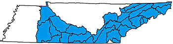

TENNESSEE RIVER
 Almost 8,300 miles of rivers and streams are part of the
Tennessee River Basin. The Tennessee Valley Authority (TVA) manages the
basin to minimize flooding, provide hydropower and maintain year-round
navigation on major rivers.
Almost 8,300 miles of rivers and streams are part of the
Tennessee River Basin. The Tennessee Valley Authority (TVA) manages the
basin to minimize flooding, provide hydropower and maintain year-round
navigation on major rivers.
What we call the Tennessee River was once called "Wahatchee," or great river, by the the Cherokee Nation. The more familiar "Tanasi" was the Cherokee capitol before 1730. In that year, the Cherokee Nation moved their capitol to Echota on the Little Tennessee River.
The Tennessee River is the major feature in the drainage. Water collected from all watersheds in the basin flow into it before emptying into the Ohio River in Kentucky, then into the Mississippi River. The watersheds in the Tennessee River basin are varied. The extreme northeastern part of the basin is mountainous; west of that, the terrain tends to be characterized by deep valleys. The southern edge of the basin (in Tennessee) varies from being relatively level to hilly.
The watersheds in the Tennessee River drainage vary from undeveloped, to agricultural to highly urbanized. Major water resources include Boone, Cherokee, Chickamauga, Chilhowee, Douglas, Norris, Fort Loudoun, Fort Patrick Henry, Guntersville, Kentucky Lake, Melton Hill, Nickajack, Normandy, Ocoee, Pickwick Lake, South Holston, Tellico, Tims Ford, Watauga, Watts Bar, and Woods Reservoirs.
 In the northeastern part of the Tennessee River Basin, major
inflows come from the Clinch River, Holston River, Powell River and Watauga
River. Because of the terrain, geology and undeveloped character of the
watersheds, the Clinch, Holston and Powell Rivers are extremely diverse
in fishes and mussels. In the eastern part of the drainage, the French
Broad, Little Tennessee, Nolichucky and Pigeon Rivers make major water
contributions, while the Hiwassee, Ocoee and Sequatchie Rivers contribute
from the southeast. At the southern end of the basin, the Elk River flows
to the Tennessee River (in Alabama after originating in Tennessee), while
the Buffalo and Duck Rivers empty into the Tennessee River at the western
edge of the basin.
In the northeastern part of the Tennessee River Basin, major
inflows come from the Clinch River, Holston River, Powell River and Watauga
River. Because of the terrain, geology and undeveloped character of the
watersheds, the Clinch, Holston and Powell Rivers are extremely diverse
in fishes and mussels. In the eastern part of the drainage, the French
Broad, Little Tennessee, Nolichucky and Pigeon Rivers make major water
contributions, while the Hiwassee, Ocoee and Sequatchie Rivers contribute
from the southeast. At the southern end of the basin, the Elk River flows
to the Tennessee River (in Alabama after originating in Tennessee), while
the Buffalo and Duck Rivers empty into the Tennessee River at the western
edge of the basin.
Originating where the Holston and French Broad Rivers meet in Knox County, the Tennessee River passes through a series of reservoirs that provide hydropower, flood control and recreation for millions of Tennesseans: Fort Loudoun Reservoir at the outset, then Watts Bar Reservoir, Chickamauga Reservoir, and Nickajack Reservoir. Finally, the Tennessee River leaves the state near Chattanooga for Alabama, only to reappear in Hardin County at Pickwick Lake. From there, the river remains impounded as Kentucky Lake all the way to the Tennessee/Kentucky border.
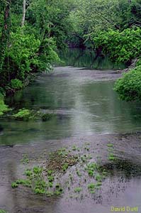
The Obed/Emory watersheds, nationally-known for their untamed rivers and rugged terrain, are the site of Tennessee’s only national Wild and Scenic Rivers.
To learn more, click on a watershed below: