


CONASAUGA RIVER
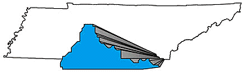
Located in the southeastern part of the state, over 50 square miles of the Conasauga River Basin are within Tennessee’s borders.
Water collected by the Conasauga River watershed in Tennessee flows through areas of incredible biological diversity in Georgia before emptying into the Gulf of Mexico. The watershed is heavily forested and has mostly a hilly character. Many rare fishes and mussels are found in this watershed which barely includes Tennessee.
CONASAUGA RIVER WATERSHED
| The Conasauga River watershed includes parts of Bradley and Polk Counties and drains 124 square miles before crossing into Georgia. Boating, fishing and hunting take place in this mostly forested watershed. The Conasauga River is included in the State Scenic River System because of its natural river qualities. |
|
| NSQ
= Natural/Scenic Quality RF = Recreational Fishing |
RB
= Recreational Boating WQ = Water Quality |
STREAM DESCRIPTION
| Stream | NSQ | RB | RF | WQ |
| CONASAUGA RIVER | 1 | 1 | 1 | |
| COAHULLA CREEK | 3 | 3 | 1 | |
| MILL CREEK | 2 | 1 | ||
| OLD FORT CREEK | 1 | |||
| SHEEDS CREEK | 1 | 1 | ||
| SUGAR CREEK | 3 |
The great explorer Hernando de Soto is believed to be the first European to refer to the Conasauga, which means "River of the Great Leaves." The name refers to the Chickamauga word for the large leaves of the cucumber magnolia tree.
