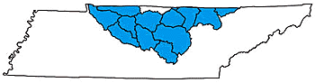

CUMBERLAND RIVER
 Almost 3,400 miles of rivers and streams are part
of the Cumberland River Basin. The U.S. Army Corps of Engineers-Nashville
District manages the basin in order to minimize flooding and maintain
year-round navigation on major rivers.
Almost 3,400 miles of rivers and streams are part
of the Cumberland River Basin. The U.S. Army Corps of Engineers-Nashville
District manages the basin in order to minimize flooding and maintain
year-round navigation on major rivers.
"Warioto" is the name the Shawnee people gave the Cumberland River long before the first white settlers arrived. Chief Little Carpenter first showed Dr. Thomas Walker of the Transylvania Land Company the Cumberland Gap, explaining that this was a bloody place because of the hostilities between the Shawnee and Cherokee peoples. Seeing a similarity, Dr. Walker renamed it Cumberland because of the hostile and sometimes bloody way the Earl of Cumberland treated his subjects.
The Cumberland River is the major feature in the basin. The Cumberland River empties into the Ohio River in Kentucky, which then joins the Tennessee River and flows into the Mississippi River. The Cumberland River Basin is varied in its landscape. Watersheds along the northern portion can be level, hilly or mountainous, with elevations exceeding one thousand feet above sea level. Those watersheds in the center generally are of lower elevation, averaging about six hundred feet above sea level and varying from rolling hills to relatively level landscapes.
Heavily forested lands, farmlands, mineral-rich lands and urban areas can be found in the watersheds of the Cumberland River Basin. Major reservoirs include Center Hill Lake, Cheatham Lake, Cordell Hull Reservoir, Dale Hollow Reservoir, Lake Barkley, Old Hickory Lake and Percy Priest Lake.
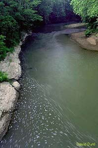
 In the eastern portion of the basin, the Big South Fork watershed is remarkable for its
biological diversity and undeveloped streams. The central portion of the basin is
characterized by scenic and pastoral rivers, particularly evident in the Caney Fork and
Collins River watersheds. The Harpeth River and Red River watersheds are typical of the
slow-moving pastoral rivers found in the western portion of the basin.
In the eastern portion of the basin, the Big South Fork watershed is remarkable for its
biological diversity and undeveloped streams. The central portion of the basin is
characterized by scenic and pastoral rivers, particularly evident in the Caney Fork and
Collins River watersheds. The Harpeth River and Red River watersheds are typical of the
slow-moving pastoral rivers found in the western portion of the basin.
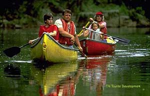
In the eastern end of the basin, entering Tennessee from Kentucky, the Cumberland River passes through a series of reservoirs and provides power, recreation and flood control for millions of Tennesseans. Passing through Nashville, Ashland City and Clarksville, the Cumberland becomes a true "working river," providing the backdrop for construction, industry, commercial musseling, and entertainment. Finally, the Cumberland River is transformed into Lake Barkley, which provides opportunities for watersports and fishing before entering Kentucky in the western end of the basin.
To learn more, click on the watershed of your choice: