To protect your rivers,
protect your mountains.
Emperor Yu of China (1600 B.C.)
Helpful Links
 Introduction (Watershed Home)
 Watershed Management Cycle
 Benefits
 Public Participation
 Watershed Management Plans
 Information on TMDLs
Other Watershed Information
 Volunteer Monitoring Fact Sheet - FAQ
 State of Tennessee Unified Watershed Assessment and Restoration Plan
 Tennessee Rivers Assessment
 Rivers Assessment Database (exit TDEC)
Introduction
The Watershed Approach is a decision making process that reflects a common strategy for information collection and analysis as well as a common understanding of the roles, priorities, and responsibilities of all stakeholders within a watershed. The Watershed Approach is based on the concept that many water quality problems, like the accumulation of pollutants or nonpoint source pollution, are best addressed at the watershed level. In addition, a watershed focus helps identify the most cost-effective pollution control strategies to meet clean water goals.
A watershed can be defined as the entire land area that ultimately drains into a particular watercourse or body of water.Watersheds can be many different shapes or sizes. Everyone lives in a watershed. Tennessee refers to watersheds by their proper name as well as by a grouping of numbers. This set of numbers is called the watershed's Hydrologic Unit Code, or HUC. The HUC can range from 2 to 16 digits long, more digits indicating a smaller and smaller portion of the watershed is represented.
Watersheds are appropriate as organizational units because they are readily identifiable landscape units with readily identifiable boundaries that integrate terrestrial, aquatic, and geologic features. Focusing on the whole watershed helps reach the best balance among efforts to control point source pollution and polluted runoff as well as protect drinking water sources and sensitive natural resources such as wetlands.
Four main features are typical of the Watershed Approach: 1) Identifying and prioritizing water quality problems in the watershed, 2) Developing increased public involvement, 3) Coordinating activities with other agencies, and 4) Measuring success through increased and more efficient monitoring and other data gathering.
An additional characteristic of the Watershed Approach is that it complements and coordinates other environmental activities. This allows for close cooperation with local citizen groups, local governments, other state agencies, and federal agencies. When all permitted dischargers are considered together, agencies are better able to focus on those controls necessary to produce measurable improvements in water quality. This also results in a more efficient process: It encourages agencies to focus staff and financial resources on prioritized geographic locations and makes it easier to coordinate between agencies and individuals with an interest in solving water quality problems.
Traditional activities like permitting, planning, and monitoring are also coordinated in the Watershed Approach. A significant change from the past is that the Watershed Approach encourages integration of traditional regulatory (those addressing point source pollution) and nonregulatory (those addressing nonpoint sources of pollution) programs.
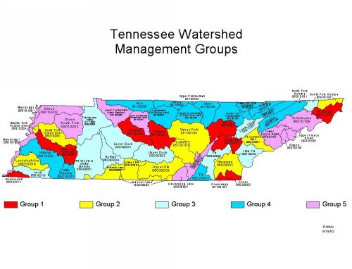
Tennessee is composed of fifty-four watersheds corresponding to the 8-digit USGS Hydrologic Unit Codes (HUC-8). These watersheds, which serve as geographic management units, are combined in five groups according to year of implementation.

Watershed Groups in Tennessee's Watershed Approach to Water
Quality.
To view larger map, click
on image.
| West | Middle | East |
|---|---|---|
| GROUP 1 | ||
| Nonconnah South Fork of the Forked Deer |
Stones |
Watts Bar Lake* Ocoee Conasauga Emory Watauga |
| GROUP 2 | ||
| Loosahatchie North Fork of the Forked Deer Forked Deer |
Collins Caney Fork Wheeler Lake Upper Elk Lower Elk Pickwick Lake |
Hiwassee Fort Loudoun Lake* South Fork Holston* |
| GROUP 3 | ||
| East Fork Clark's Wolf Tennessee Western Valley (Beech) Tennessee Western Valley (KY Lake) |
Upper Duck Lower Duck Buffalo |
Lower Tennessee* Little Tennessee Lower Clinch North Fork Holston South Fork Holston* |
| GROUP 4 | ||
| Hatchie Little Hatchie |
Red · Barren Cumberland (Old Hickory Lake) Upper Cumberland (Cumberland Lake) Upper Cumberland (Cordell Hull Lake) Obey |
South Fork Cumberland Upper Cumberland Powell Upper Clinch Holston Lower Tennessee* |
| GROUP 5 | ||
|
Mississippi |
Lower Cumberland (Lake Barkley) Lower Cumberland (Cheatham Lake) Guntersville Lake |
Sequatchie Upper French Broad Lower French Broad Pigeon Nolichucky |
*Activities in some watersheds have been split between watershed groups.


