


Historical Significance
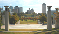 With the urban building boom in downtown Nashville during the late 1950s and early 1960s, the Tennessee State Capitol disappeared from sight on the east, west and south sides. The northern side of the Capitol was not conducive to the construction of skyscrapers due to the swampy conditions that existed in many areas between the Capitol and the Cumberland River. Ironically, the historic French Lick that attracted wildlife, Indians, trappers and settlers to what would become Nashville also preserved the remaining view of the Capitol and became the home of the Bicentennial Capitol Mall State Park. In order to save the one remaining view of the Capitol and to commemorate Tennessee's 200th birthday, the concept of a mall similar to the one in Washington, DC, took shape.
This is the point that all state mile markers are zeroed from.
Topography: It is easy to see why Tennessee has three grand divisions. West Tennessee is flat and has delta type terrain. Middle Tennessee is rocky and hilly. East Tennessee is Mountainous. That is why we have the three stars on the flag.
With the urban building boom in downtown Nashville during the late 1950s and early 1960s, the Tennessee State Capitol disappeared from sight on the east, west and south sides. The northern side of the Capitol was not conducive to the construction of skyscrapers due to the swampy conditions that existed in many areas between the Capitol and the Cumberland River. Ironically, the historic French Lick that attracted wildlife, Indians, trappers and settlers to what would become Nashville also preserved the remaining view of the Capitol and became the home of the Bicentennial Capitol Mall State Park. In order to save the one remaining view of the Capitol and to commemorate Tennessee's 200th birthday, the concept of a mall similar to the one in Washington, DC, took shape.
This is the point that all state mile markers are zeroed from.
Topography: It is easy to see why Tennessee has three grand divisions. West Tennessee is flat and has delta type terrain. Middle Tennessee is rocky and hilly. East Tennessee is Mountainous. That is why we have the three stars on the flag. Music: This map shows that Tennessee is noted not only for Country Western, but blues, jazz, rock, gospel and many types of music.
Parks: Anywhere you travel in Tennessee, you are within thirty minutes of a state or national park.
Populations: You can see how Tennessee's populations are centered across Tennessee.
Trails: You notice that not only Indian Trails and pioneer trails are identified, but also Interstates since they are part of our modern day trails.
This map is a copy of the best map available in 1796 when Tennessee became a state.
The Missippian Indians were in the region until approximately 1450. Then the Shawnee came in from the North, the Chickasaw from the West, the Cherokee from the East and the Creek from the South
The Geology map shows the foundation of Tennessee. The area of Middle Tennessee shows Ordovician Limestone. Ordovician is soft and porous and is noted for having caves and sinkholes. During World War II, Middle Tennessee was selected for the largest War Games in the history of man due to our geology and topography. The 200-foot Granite state map highlights the major roads, 95 counties, rivers, interesting geographic formations and details of each county. It is located at the entrance point of the park on James Robertson Parkway. The map is designed to scale. 12 inches is equal to 2½ miles.
 The railway trestle stands as a reminder of the importance of railroading in Tennessee's history. The trains have traveled here since 1859 and were an important strategic point during the War Between the States.
Under the west end of the trestle are restrooms, and under the east end is a visitor center and gift shop.
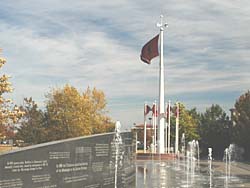
The Rivers of Tennessee Fountains
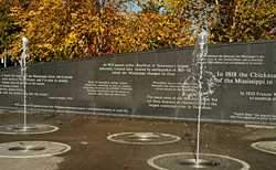 Visitors, after passing under the railway trestle, enter an area containing 31 vertical water fountains, one for each of the predominant waterways in Tennessee.
The River Walk is accented with a bowed and arched granite wall with inscriptions about Tennessee's waterways.
 Located on each end of the River Walk are clusters of Tennessee flags. Each cluster contains one large 12 x 18-foot flag, and eight smaller 5 x 8-foot flags for a total of 18 Tennessee flags. The 16 small flags represent Tennessee being the 16th state admitted to the union June 1, 1796. The two large flags represent the states bicentennial celebration.
The American flag is not flown in the mall since the park is an extension of the State Capitol, which flies the American Flag high above the Bicentennial Capitol Mall State Park. Along the west side of the park, a 1,400-foot Wall of History is engraved with historic events that have occurred over the past two centuries. A granite pylon marks each ten-year period along the wall. The wall 'breaks' at the time of the Civil War to represent the divisive nature of the war on the state.
Read the engraved items from the Wall of History (pdf)
McNairy Spring is a monument and fountain that represents the founding of Tennessee. The fountain is on top of the sulphur spring that fed the Old French Lick Creek. The greenway trail is located on top of the creek today and leads you to the Cumberland river.
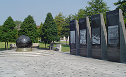 The World War II Memorial was dedicated on November 11, 1997. It features an 18,000 lb. granite globe floating on 1/8 inch of water. The countries on the globe are as they were during the war. There is a small map of Tennessee with lines showing the mileage to different theatres of war. Visitors may stop the globe and turn it with their hands.
The Memorial also has large granite markers that give a brief history of such historic events as the bombing of Pearl Harbor, the Battle of the Bulge, as well as scenes from here in Tennessee by using sand blasting engravings of actual photographs on the markers.
There is a bench that lists the seven Congressional Medal of Honor winners from Tennessee. A time capsule will be opened on November 11,2045 and contains lists of donors, persons that served, and a separate list of the Tennesseans that served and were killed in combat.
The Memorial is located near the North end of the Park at the 1946 marker and is a must-see for any visitor.
Carillons and the Court of 3 Stars
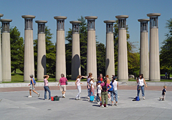 The Court of 3 Stars is a focal point of the park located at the northern end near Jefferson Street. Made of red, white and blue granite, this area represents the three grand divisions of the state - East, Middle and West Tennessee. This is also the site of a 95-bell carillon representing Tennessee's musical heritage. The 95 bells represent the citizens of Tennessee's 95 counties. A 96th bell, known as the answer bell, is located on the grounds of the State Capitol and rings in answer to the 95 bells, symbolizing government answering to the people. The carillons are the largest in the world.
The Civilian Conservation Corps Memorial is located at the North end of Bicentennial Mall on 7th Avenue. CCC Veterans and President Franklin Delano Roosevelt's grandson David dedicated the memorial April of 1998. The beautiful granite marker reminds us that this unique program laid much of the groundwork for what we enjoy today in our State and National Parks.
The Court of 3 Stars is a focal point of the park located at the northern end near Jefferson Street. Made of red, white and blue granite, this area represents the three grand divisions of the state - East, Middle and West Tennessee. This is also the site of a 95-bell carillon representing Tennessee's musical heritage. The 95 bells represent the citizens of Tennessee's 95 counties. A 96th bell, known as the answer bell, is located on the grounds of the State Capitol and rings in answer to the 95 bells, symbolizing government answering to the people. The carillons are the largest in the world.
The Civilian Conservation Corps Memorial is located at the North end of Bicentennial Mall on 7th Avenue. CCC Veterans and President Franklin Delano Roosevelt's grandson David dedicated the memorial April of 1998. The beautiful granite marker reminds us that this unique program laid much of the groundwork for what we enjoy today in our State and National Parks.Planters each represent East, Middle and West Tennessee. You will notice as you walk the Walkway of Counties the plantings will change from East to West Tennessee symbolizing what a diverse state we live in from the mountains of East Tennessee to the flat farm land of West Tennessee. The east side of the park features the Walkway of (delete the) Counties that contains a time capsule from each of Tennessee's 95 counties. These time capsules will not be opened until the Tercentennial in 2096. This 95-county historical journey highlights the topographical features of each region of the state, depicting the flat, mountainous and rolling hills sections of the state. Native trees, shrubs, ferns, grasses and wildflowers along the walkway represent the diverse vegetation found across the state. Time Capsules will be opened on June 1, on the state's three-hundredth birthday. As part of the Bicentennial celebration, many Tennesseans reserved their place in history by purchasing commemorative bricks. These granite bricks with their names are placed along the Path of Volunteers, a central tree-lined granite walkway extending down both sides of the park and terminating at the Court of 3 Stars.
