


|
COUNTY:
|
Rutherford |
ACREAGE:
|
36 |
|
7.5' QUADRANGLE:
|
Walterhill |
OWNERSHIP:
|
State of Tennessee |
|
PHYSIOGRAPHIC
PROVINCE: |
Central Basin |
YEAR DESIGNATED:
|
1995 |
DESCRIPTION: |
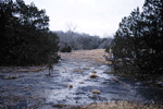 Sunnybell
Cedar Glade is a 36-acre natural area located in the Central Basin of
Middle Tennessee, twelve miles north of Murfreesboro in Rutherford County.
This site supports a rare assemblage of glade endemic plant species found
only at a small number of other locations in Middle Tennessee. The natural
area is named for the sunnybells (Schoenolirion croceum) that
are prominent in wet calcareous limestone washes of cedar glades. In springtime
the sunnybells flower profusely and create a remarkable sight. Other rare
plants that have been identified from this site include glade cleft phlox
(Phlox bifida ssp stellaria), Tennessee milk-vetch (Astragalus
tennesseensis), evolvulus (Evolvulus nuttallianus), and
pale umbrella-wort (Mirabilis albida).
Sunnybell
Cedar Glade is a 36-acre natural area located in the Central Basin of
Middle Tennessee, twelve miles north of Murfreesboro in Rutherford County.
This site supports a rare assemblage of glade endemic plant species found
only at a small number of other locations in Middle Tennessee. The natural
area is named for the sunnybells (Schoenolirion croceum) that
are prominent in wet calcareous limestone washes of cedar glades. In springtime
the sunnybells flower profusely and create a remarkable sight. Other rare
plants that have been identified from this site include glade cleft phlox
(Phlox bifida ssp stellaria), Tennessee milk-vetch (Astragalus
tennesseensis), evolvulus (Evolvulus nuttallianus), and
pale umbrella-wort (Mirabilis albida).
Cedar glades are characterized by openings in cedar-oak-hickory forest where the soil is very shallow, and often associated with karst topography. Growing conditions in these glades are very harsh, and only a few highly specialized plants adapt to these conditions. Even the more common tree species that occur in glade ecosystems like red cedar, hackberry, southern shagbark hickory and the various oaks are stunted. Like many other cedar glades of Middle Tennessee, Sunnybell Cedar Glade is underlain by Lebanon limestone formations deposited during the Ordovician Period about 500 million years ago. This is karst topography with little relief as characterized by exposed limestone outcroppings.
SITE MANAGEMENT:
Division of Natural Areas, 401 Church Street, 7th Floor L&C Annex, Nashville, TN 37243, phone (615) 532-0431.
PUBLIC ACCESS:
There is no public access.
