


Helpful Links
 The Bill: Public Chapter 232
Designated Scenic Rivers
Contact Us
Rivers Assessment
Rules for the Management of Tennessee Natural Resource Areas
Related Web Sites
TSRA
Conservation Fisheries
Wild & Scenic Rivers
NRC/USDA
American Rivers
Wetlands Regulation Center
TVA
Farm Service Agency
River Network
Nationwide Rivers Inventory
The Scenic Rivers Program was established in 1968 with the passage of the Tennessee Scenic Rivers Act. Since passage of this act, the General Assembly has designated sections of 13 rivers as State Scenic Rivers. Many of these Scenic Rivers are managed cooperatively with other local, state and federal agencies as well as with non-governmental organizations. The Scenic Rivers Program seeks to preserve valuable selected rivers, or sections thereof, in their free-flowing natural or scenic conditions and to protect their water quality and adjacent lands. The program seeks to preserve within the scenic rivers system itself, several different types and examples of river areas, including mountain streams and deep gorges of east Tennessee, the pastoral rivers of middle Tennessee, and the swamp rivers of west Tennessee. State Scenic Rivers are managed according to the Rules for the Management of Tennessee Natural Resource Areas.
Tennessee’s Designated State Scenic Rivers
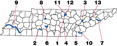
(Clickable
Image Map)
Class I - Natural River Area -That segment of the stream from the county road at Cummings Mill downstream one and one-half (1-1/2) miles.
Class II- Pastoral Area - That segment downstream from a point one and one-half (11/2) miles downstream from the county road at Cummings Mill to its confluence with Roaring River.
Class II - Pastoral River Area- The entire river, except that portion which lies within Wayne, Perry, Humphreys and Lewis counties.
Class III - Developed River Area - That portion from Melton Hill Dam upstream to Pellissippi Parkway.
Class II - Pastoral River Area - That segment which lies within the Savage Gulf natural-scientific area.
Class I - Natural River Area - The entire segment of the river in Polk County, upstream from the Highway 411 bridge.
Class II - Pastoral River Area - That segment of the Duck River beginning at Iron Bridge Road at river mile a136.4 and extending continuously to the boundary of Marshall County at river mile 173.7.
Class III - Developed River Area - That segment from the North Carolina state line to its confluence with Douglas Lake.
Class II - Pastoral River Area - The entire river except that segment lying north of Highway 100 and south of Interstate 40 in Davidson County; and except those segments located in Cheatham, Dickson and Williamson counties.
Class III - Developed River Area - Only that segment of the Harpeth River lying north of Highway 100 and south of Interstate 40; it being the specific intent to exclude all segments of the Harpeth River lying in or flowing though Cheatham, Dickson and Williamson counties.
Class I - Natural River Area - as a swamp river.
Class III - Developed River Area- That portion from the Highway 411 bridge to the North Carolina line.
Class I - Natural River Area - That segment from State Route 136 downstream two (2) miles.
Class II - Pastoral River Area - That segment downstream from a point two (2) miles downstream from State Class II - Pastoral River Area - Route 136, to its confluence with the Cordell Hull Lake.
Class I - Natural River Area - That segment from Waterloo Mill downstream to the Overton-Jackson county line.
Class II - Pastoral River Area - That segment between State Highway 136 and Waterloo Mill, and that segment downstream from the Overton-Jackson county line to its confluence with Roaring River.
Class III - Developed River Area - The entire creek
**The
Scenic Rivers web site is best viewed by these browsers:
Internet Explorer 4.0 and later
Netscape Navigator 6.0 and later
Contact:
Reggie Reeves
Division of Natural Areas Director
(615) 532-0431
[email protected]
