


| COUNTY: | Cumberland | ACREAGE: | 43 |
| 7.5' QUADRANGLE: | Ozone | OWNERSHIP: | State of Tennessee |
| PHYSIOGRAPHIC PROVINCE: |
Cumberland Plateau | YEAR DESIGNATED: | 1973 |
DESCRIPTION: |
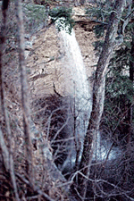
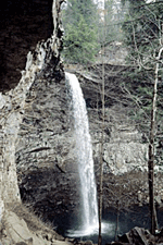 Ozone
Falls is a 43-acre natural area in Cumberland County. It receives heavy
visitation because of its close proximity to Interstate 40. Ozone Falls
plunges 110 feet over a sandstone cap rock into a deep blue, rock-strewn
pool. Fall Creek then disappears underground until it re-emerges several
feet downstream. An impressive rock house “amphitheater” can
be seen behind the falls that was created over geologic time by wind,
water, freeze/thaw, and erosion. Because of its picturesque beauty and
easy access, Ozone Falls was selected for filming scenes for the movie
“Jungle Book.”
Ozone
Falls is a 43-acre natural area in Cumberland County. It receives heavy
visitation because of its close proximity to Interstate 40. Ozone Falls
plunges 110 feet over a sandstone cap rock into a deep blue, rock-strewn
pool. Fall Creek then disappears underground until it re-emerges several
feet downstream. An impressive rock house “amphitheater” can
be seen behind the falls that was created over geologic time by wind,
water, freeze/thaw, and erosion. Because of its picturesque beauty and
easy access, Ozone Falls was selected for filming scenes for the movie
“Jungle Book.”
Small open glades occur on the bluffs that support native grasses and prairie plants. The surrounding upland vegetation is dominated by oaks and Virginia pine. An infestation of southern pine beetles killed many of the pines between 1999 and 2001. A remnant old growth mixed mesophytic forest community is found beneath the waterfall. It is comprised of eastern hemlock, white pine, magnolia, yellow birch, sugar maple, tulip poplar, and red oak and with rosebay rhododendron in the shrub layer. The stream contains many huge boulders, some the size of houses, and many small placid pools. A rugged ¾-mile trail begins along the bluff near the falls and then descends into the gorge passing a small rock house called Gamblers Den. The trail follows Fall Creek to the confluence with Renfro Creek where hikers must backtrack to return to the trailhead.
 Ozone
Falls is situated on the eastern edge of the Crab Orchard Mountains on
the Cumberland Plateau. Legend has it that the area was named “Ozone”
because of the “stimulating quality of the air” created by
the mist that is generated after the long plunge of the water. In the
1800’s, grist and sawmills had been built above the falls. The last
one was washed over the falls during a spring flood in 1900.
Ozone
Falls is situated on the eastern edge of the Crab Orchard Mountains on
the Cumberland Plateau. Legend has it that the area was named “Ozone”
because of the “stimulating quality of the air” created by
the mist that is generated after the long plunge of the water. In the
1800’s, grist and sawmills had been built above the falls. The last
one was washed over the falls during a spring flood in 1900.
SITE MANAGEMENT:
Cumberland Mountain State Park, 24 Office Drive, Crossville, Tennessee 38555, phone (931) 484-6138; Division of Natural Areas, 401 Church Street, 7th Floor L&C Annex, Nashville, Tennessee 37243, phone (615) 532-0431; Division of Natural Areas – East TN office, 3711 Middlebrook Pike, Knoxville, TN 37921, phone (865) 594-5601.
PUBLIC ACCESS:
Public access is allowed; parking and hiking trails are provided. Rappelling by the general public is prohibited. Local and county rescue squads may use the area for rescue training by permit only. For permission, contact Cumberland Mountain State Park, or the East Tennessee Natural Areas office.
DIRECTIONS:
From Crossville travel East on I-40 and exit at the Crab Orchard exit. Turn left off the exit ramp and go to the intersection of U.S. Highway 70. From Knoxville go west on I-40 and exist at Crab Orchard. From Crab Orchard exit, turn right on U.S. Highway 70 going east. The highway takes you straight to Ozone Falls, which is on the right about four miles from the interstate exit.
