Division of Air Pollution Control
PM 2.5 Monitors
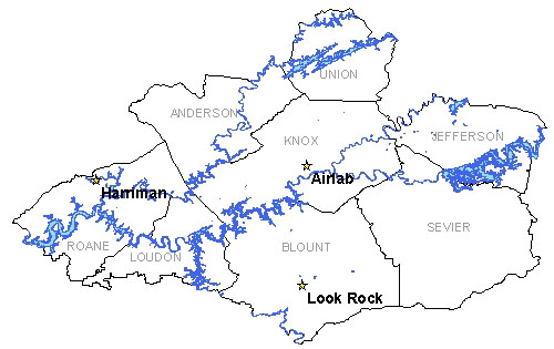
Knoxville Area PM 2.5 Monitors
The Knoxville Area (elevations under 2,500 ft.) includes , Knox, and Roane Counties in Tennessee.

Airlab Monitoring Site |
Harriman Monitoring Site |
||
| AIRS Identification Number: | 470931012 | AIRS Identification Number: | 471450004 |
|---|---|---|---|
| County: | Knox | County: | Roane |
| Forecast Area: | Knoxville Area (elevations under 2,500 ft.) | Forecast Area: | Knoxville Area (elevations under 2,500 ft.) |
| Land Usage: | Mobile | Land Usage: | Industrial |
| Elevation (Above Mean Sea Level) |
1056 feet (321.87 meters) |
Elevation (Above Mean Sea Level) |
787 feet (239.88 meters) |
| Latitude: (Degrees) |
36.0183436 (36°1'50.06" N) |
Latitude: (Degrees) |
35.9386 (35°56'51.6" N) |
| Longitude: (Degrees) |
-83.87614417 (83°52'36.87" W) |
Longitude: (Degrees) |
-84.5439 (84°32'23.4" W) |
| Years of Operation | 3 years | Years of Operation | 1 years |
| Operated by: | Knox County | Operated by: | TN Dept. of Environment and Conservation |
Look Rock Monitoring Site |
|||
| AIRS Identification Number: | 47090101 | ||
| County: | Blount | ||
| Forecast Area: | Knoxville Area (elevations under 2,500 ft.) | ||
| Land Usage: | Pine-Oak Forest | ||
| Elevation (Above Mean Sea Level) |
2601 feet (792.78 meters) |
||
| Latitude: (Degrees) |
35.6322 (35°37'13.2" N) |
||
| Longitude: (Degrees) |
-83.9422 (83°56'13.2" W) |
||
| Years of Operation | 3 years | ||
| Operated by: | National Park Service | ||
Governor Bill Haslam
Featured Sites
Fleming Training CenterOutreach Initiatives
Tennessee State Parks
TVA Kingston Update
TN Environmental Conference

