Every faithful Tennessean I ever met is tired of hearing three
spurious claims.
1. We hate for Yankees to say that we don’t know how to drive
in the snow. When NASCAR becomes a 12-month sport, they’ll see different.
2. We are appalled that other states are allowed to advertise
questionable food products as "barbecue."
3. We get deeply offended when someone from yon side of the
Mississippi River implies that our mountains are too short.
The last one is the most unreasonable. If you can’t find
inspiration on the mountaintops in the greenest state in the land of the free, you’ve
been in the sun too long (not uncommon out there) and your brain has been on an alpine
low-oxygen diet.
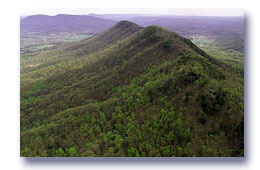
We’ve got plenty of peaks, summits, and pinnacles to be proud
of, not to mention outstanding knobs, "pints," ridges, hills, and tall places.
It is unfortunate that some of our most famous elevated topography doesn’t exist,
like Davy Crockett’s lofty birthplace and home-sweet-home, Rocky Top.
It’s a bit humiliating that our state high point,
Clingman’s Dome, is half-owned by North Carolina, but it’s not their high
point. And that Rock City, with its amazing state-watching observatory, is entirely in
Georgia.
Nonetheless, Tennessee’s heights deserve respect. According the
Ron Tagliapietra, author of The Southern Sixers, a guide to all the
peaks over 6,000-feet in the South, all 40 such peaks are in North Carolina and/or
Tennessee, with Tennessee owning a share of nine of the top 15. If one were to hike to all
40, certification of the feat could come from the Asheville, N.C.-based oversight group,
"South Beyond 6,000."
I had heard of such systematic pursuits of peaks, about well-heeled
adventurers who scale the tallest mountain on each continent. I wondered if anyone had
systematically visited Tennessee’s summits. Did anyone even know, for instance, where
to find the tallest point in Shelby County?
Advancing to the map library of the University of Tennessee, I
encountered thick reefs of steel cabinets that held the wonderfully-green "quad"
maps produced by the United States Geological Survey, splayed with river courses and
roadways, knitted and stacked with contour lines indicating elevations.
Starting with what I presumed would be a straightforward exercise,
finding the highest peak in mountainous Johnson County, I soon realized that there was
work involved in this game. Our Geological Survey had not placed a benchmark, with precise
elevation, on very many peaks after all, and adding up 20-foot contour lines was a
necessary chore. Plus, this nationwide grid of quad maps relentlessly chopped through
state and county lines, so an eye-stretching search of 11 clumsy 27-inch-by-22-inch maps
was required to spot the unheralded Snake Mountain, on the Zionville, N.C., quad. It took
map pulling for just one more county and I was exhausted, without hiking a foot. It would
require 803 quads to sort out Tennessee’s secret summits.
Fortunately, Jim Minton, Head of the U.T. Map Library, has had an
eye for cartographic trivia. He had noted a Web site, which led to a small, loose
aggregation of enthusiasts, known as "county high pointers." These most
hard-core practitioners have a deep desire to claim the summit of any and every county
anywhere in America, even Louisiana. These devotees had already carefully assembled the
Tennessee list and every other state’s list.
Andy Martin, of Tucson, Arizona, configured or collected these lists
for his self-published book, County High Points, in 1994. He is also the
current recognized leader in the visitation of Tennessee county high points. Like most of
his peers, he started as a member of the Highpointers Club, an organization for folks
seeking to reach the highest elevation in all 50 states.
"People began to run out of states to go after,"
he explained, "so the next level of granularity is counties. It has more
appeal to people who are looking for interesting hikes in their own neighborhood."
Another experienced hiker, John Mitchler, of Golden, Colo., took up
the pursuit of county high points (county "HPs") when he saw Martin’s
lists: "I think some people like organization better than others. Some people
spend a lot more time making a ‘to-do’ list, or a grocery list. It is a way of
setting a goal. You take satisfaction from progress, in addition to doing the physical
effort and seeing the countryside and mountainsides."
Even so, this could be the most height-obsessed bunch in Tennessee
since the Mound Builders. Naturally, they have their own language, rules, and heroes. "Peakbagging"
is their half-derisive term for the list-driven "collection" of
high points. A "twofer" is a point that straddles county lines so
the peakbagger gets credit for two county HPs with one visit. (Clingman’s Dome is the
HP for Sevier County, and Swain County, N.C., for instance.) A "county glob"
is the number of contiguous counties in which the county HP has been bagged. "Martinizing,"
named for pioneer Andy Martin, refers to peakbagging with the least possible expenditure
of energy, such as driving up to a benchmark, flipping open the car door, and sweeping a
foot across the brass plate.
Martinizing is not the preferred method of peakbagging for all those
in the pastime. Some aim for credit in the "he-man" or "she-ra"
category, requiring a hike with a 1,000-foot gain in elevation. But even some of the
serious climbers or hikers, like John Mitchler, who was the first to complete the Colorado
state list, are tempted by the "Front-Runners List," which tracks the state
leaders and current champions in dozens of other categories.
One of Mitchler’s most formidable achievements, carried out
with veteran HPer Dave Covill, was a 24-hour run through Kansas in June, 1997, bagging 24
county HPs in 1,271 miles, drinking coffee, listening to radio tunes, road navigating, and
hiking by headlamp, full moon and heat lightening. The expedition required no oxygen
bottles, crampons, or Sherpas, but, then again, it has never been duplicated.
To properly bag a peak or collect a county HP for credit, pay
attention to "The Rules," often called "Fred’s Rules,"
promulgated by professor Fred Lobdell, a birdwatcher, geologist, and avid HPer from North
Carolina. A county HP is defined as the highest natural landform in a county and
peakbaggers have no interest in the tallest buildings, power poles, trees, levees, etc.
When more than one site could be a county HP, then all must be visited. (Lauderdale
County, for instance, has 24 areas that top out with a 520-foot contour.) If access to the
high point is restricted, you cannot get credit by walking on the closest high ground.
Negotiating with the landowner is considered to be part of the challenge and enjoyment of
the activity, and the only right way to get access.
In truth, not many have taken on Tennessee’s terrain, as the
county HP movement has been focused on New England and the West. However, Andy Martin
hill-hopped from Lake County to Knox County in the summer of 1999, putting 20 Tennessee
counties on his 70-county Pacific-to-Atlantic corridor of county HPs, now known as
"Martin’s Lane." His best memory was of friendly landowners, curious about
their stature as owners of a county HP. He was surprised by the rugged hiking on the
eroded loess banks of Dyer County, charmed by the Maple Creek fire tower at Natchez Trace,
punished by poison ivy and a wet, briar-filled thicket in Loudon County, and most
impressed by the view from Lookout Mountain, Hamilton County’s high point.
Looking over the Tennessee HPs, it is easy to understand why so many
are found near county or state lines. No one in their right mind would have laid out a
county with a mountain in the middle of things. Sullivan County’s HP, ranked ninth in
elevation, is the highest one completely within Tennessee territory, as the eight higher
county HPs are set on the North Carolina border. Good mountains make good neighbors.
Cross Mountain, our highest peak in the Cumberland Mountains, is the
only true Tennessee twofer, representing both Anderson and Campbell counties’ high
point. It was the site of an Air Force radar installation during the Cold War, reportedly
staffed by more than 300 personnel.
Cannon County has sole possession of the highest Tennessee point
west of the Plateau, Short Mountain, which at 2,092-feet in elevation upstages numerous
Plateau counties, including Fentress, Pickett, and Franklin. And Wilson County puts up a
higher-than-expected promontory in the heart of the Central Basin, the 1,362-feet-high
backbone of Mount Defiance, which exceeds any of the hilltops in the rumpled Western
Highland Rim.
Many of us have repeated the falsehood that Nathan Bedford Forrest
State Park’s Pilot Knob is the highest point in West Tennessee. It is a cruel
surprise that Pilot Knob is not even the Benton County HP. There are, in fact, 15 West
Tennessee peaks on the list higher than our once-thought-to-be-so-special riverfront knob.
Chester County’s Sand Mountain, at 740-feet, is the glory, the rooftop, the apex of
West Tennessee.
Perhaps the best lesson is that height doesn’t mean everything.
Old Elias Mitchell literally broke his neck to prove that North Carolina owned the highest
mountain in the East. He might have been better off sunning at the beach. But, like the
grouse hunter who doesn’t shoot, or the fisherman who returns his catch to the water,
the county HPers have a handy excuse for rattling their beloved maps, adventuring down
unknown highways, and getting their heads above the surrounding plains or valleys.
It’s likely, in Tennessee, they’ll get a face full of fresh breeze, an eyeful of
scenery, and an earful of green music, along with their peak.
(Bob Fulcher is a regional interpretive specialist for
Tennessee State Parks.)