

Photo Galleries Park Information Hours of Operation
8 a.m. to sunset, year-round  From Harriman take Hwy. 27 North to Wartburg. Turn right (East) on Hwy. 62. Travel 2 miles and turn left on Flat Fork Road. Travel 4 miles to the park entrance. |

Frozen Head State Park
964 Flat Fork Road | Wartburg , TN 37887
Office: 423-346-3318 | Fax: 423-346-6629
![]()
![]()
![]()
![]()
![]()
![]()
![]()
![]()
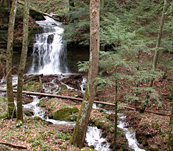
Frozen Head State Park and Natural Area is situated in the beautiful Cumberland Mountains of eastern Tennessee. The 13,122 acres of relatively undisturbed forest contain some of the richest wildflowers areas in Tennessee. The mountainous terrain varies from an elevation of 1,340 feet to over 3,000 feet on 16 different mountain peaks. Frozen Head, elevation of 3,324, is one of the highest peaks in Tennessee west of the Great Smoky Mountains. From its observation tower on a clear day, one can plainly see the Cumberland Plateau, Tennessee Ridge and Valley, and the Great Smoky Mountains. In winter, the mountain peaks are often capped with snow or ice while the lower valleys remain unadorned, thus giving the park's namesake, Frozen Head. The park's lush vegetation, small streams, waterfalls and beautiful mountains make Frozen Head one of Tennessee's most scenic parks. Frozen Head State Park and Natural Area is situated in the beautiful Cumberland Mountains of Eastern Tennessee near Wartburg. The 11,876 acres of relatively undisturbed forest contains some of the richest wildflower areas in Tennessee. The mountainous terrain varies from an elevation of 1,340 feet to over 3,000 feet on 14 different mountain peaks.
In 1988, all of the Frozen Head State Park acreage except approximately 330 acres was classified as Natural Area. The 330 acres lie in the Flat Fork and Judge Branch watersheds.
For more information, visit the Natural Areas web site.Gift Shop
The visitors' center gift shop carries a variety of souvenirs and gifts. A topographic trail map can also be purchased here. All trails opened to the public are highlighted in red; hikers and backpackers are required to stay on opened trails. Off-trail use is not permitted.Historical Significance
History of Frozen Head State ParkIn the early 1800's, settlers from the mountainous regions of Scotland and Wales moved into the area and built homesteads in the high mountains. The German settlers established the nearby town of Wartburg. The mountains were rich in natural resources and after the Civil War, land speculators and northern industrialist began buying land for its valuable timber and coal reserves.
In 1894, the state acquired a large area in Morgan County as a location for the Brushy Mountain State Prison. The coal was deep mined using convict labor and the forest area supplied the timber for the mine props.
Between 1911 and 1915, the forest was heavily cut over in a steam skidder operation. The timber was sold and the Emory River Lumber Company built a railroad from the mill site at Gobey over which the logs were hauled. In later years, portable sawmills re-worked the area, cutting practically all of the merchantable timber. Logging was completed by about 1925.
In May of 1933, Governor McAllister proclaimed a large part of the prison lands as Morgan State Forest to be managed by the Forestry Division. Shortly afterwards, a Civilian Conservation Corps (CCC) camp was established on the Forest. Inasmuch as forest fires and trespass protection was of primary importance, a lookout tower was erected on Frozen Head Mountain. Fire control roads and trails were constructed, the boundaries surveyed and marked and a ranger's headquarters was built along Flat Fork Creek. The CCC camp disbanded in 1941 at the onset of W.W.II.
In the fall of 1952 the entire state forest was burned by the worst forest fire season in state history. The forestland was transferred to the Parks Division in 1970 and the area was designated as Frozen Head State Park.
In 1973, an additional 2,650 acres were transferred from the remaining acres at Brushy Mountain Prison. In recent years, two other small land acquisitions have brought the total to 13,122 acres. In 1988, all of the Frozen Head State Park acreage except approximately 330 acres was classified as Natural Area. The 330 acres lie in the Flat Fork and Judge Branch watersheds below the 1600-foot elevation contour line, and all present and future park developments will be limited to this recreation area. In 1894 the state acquired a larger area in Morgan County for the Brushy Mountain State Prison. Coal was deep mined by convict labor and the trees were harvested to supply timbers for the mines. The land was transferred to State Parks in 1970 and became Frozen Head State Park. In 1988 most of the state park acreage was classified as a State Natural Area.
