


| COUNTY: | White | ACREAGE: | 1133 |
| 7.5' QUADRANGLE: | Lonewood | OWNERSHIP: | State of Tennessee |
| PHYSIOGRAPHIC PROVINCE: |
Cumberland Plateau | YEAR DESIGNATED: |
1973 |
DESCRIPTION: |
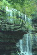 Virgin
Falls is 1,133-acre natural area located adjacent to the Bridgestone Firestone Centennial Wilderness in White County. The natural
area is named for Virgin Falls, which is formed by an underground stream
that emerges from a cave, then drops over a 110-foot high cliff before
disappearing into another cave at the bottom of the sink. The area is
noted for its unique geological features and several (additional) other
waterfalls including Big Laurel, Sheep Cave Falls, and Big Branch Falls.
The caves at Virgin Falls include Big Laurel, Sheep Cave, and Virgin Falls
Cave. The sinkholes at Virgin Falls, such as Virgin Falls Sink and Sheep
Cave Sink, are characteristic of karst features found on the Cumberland
Plateau. The Caney Fork River and its tributaries drain the area and contribute
to the formation of the gorge. The Caney Fork Overlook provides a dramatic
view of Scott's Gulf and the Caney Fork River 900 ft below.
Virgin
Falls is 1,133-acre natural area located adjacent to the Bridgestone Firestone Centennial Wilderness in White County. The natural
area is named for Virgin Falls, which is formed by an underground stream
that emerges from a cave, then drops over a 110-foot high cliff before
disappearing into another cave at the bottom of the sink. The area is
noted for its unique geological features and several (additional) other
waterfalls including Big Laurel, Sheep Cave Falls, and Big Branch Falls.
The caves at Virgin Falls include Big Laurel, Sheep Cave, and Virgin Falls
Cave. The sinkholes at Virgin Falls, such as Virgin Falls Sink and Sheep
Cave Sink, are characteristic of karst features found on the Cumberland
Plateau. The Caney Fork River and its tributaries drain the area and contribute
to the formation of the gorge. The Caney Fork Overlook provides a dramatic
view of Scott's Gulf and the Caney Fork River 900 ft below.
Hiking to Virgin Falls and back to the parking area is a five to eight hour hike depending on your pace and whether you hike to the Caney Fork Overlook and/or the Caney Fork River. The trail leaving the parking area meanders down to the Big Branch of the Big Laurel Creek through an upland oak-hickory/chestnut oak hardwood forest crisscrossing a fern dominated upland drainage. Upon descending into the gorge the vegetation changes to hemlock and mixed mesophytic forest which includes maples, oaks, tulip poplar, hickories, buckeye, basswood, cherry, yellow birch, sycamore and many more species. Mountain laurel, magnolia and several ericaceous shrubs (such as various wild blueberries) are common along the trail. The trails pass by small rockhouses, boulder fields, sinks, caves, and waterfalls on route to Virgin Falls where the trail ends. The distance to Virgin Falls is four miles one way. There are designated camping sites off the trail (see map). There is no camping allowed above Virgin Falls. The streams at Virgin Falls are noted for flash flooding, so keep up-to-date on the weather conditions before hiking into the area.
Virgin Falls is within the greater Scott's Gulf region and adjacent to the Bridgestone/Firestone Centennial Wilderness Area (www.centennialwilderness.com). It was previously a Bowater Pocket Wilderness Area until it was purchased by the State in 1996. The deep gorges are heavily wooded and are ecologically diverse supporting various aged second growth mixed mesophytic and oak-hickory forest. The forests and geologic features make Virgin Falls one of Tennessee’s favorite destinations. Please be sure to respect the resource and take out all litter and trash, and if camping, please leave your campsite inviting for the next campers.
SITE MANAGEMENT:
Division of Natural Areas, 401 Church Street, 7th Floor L&C Tower Annex, Nashville, TN 37243, phone (615) 532-0431.
PUBLIC ACCESS:
Public access is allowed; parking and hiking trails are provided. Backcountry camping is permitted at designated campsites.
DIRECTIONS:
Virgin Falls is located southeast of Sparta and is accessible via Highway 70. Go to the community of DeRossett, 11 miles east of Sparta, turn onto Eastland Road and proceed six miles to Scott's Gulf Road. There, you will see a sign for the Bridgestone/Firestone Centennial Wilderness. Turn right onto Scott's Gulf Road and proceed two miles to the parking area and trailhead on the right side of the road.
