


| COUNTY: | Pickett, Fentress and Scott | ACREAGE: | 1,500 |
| 7.5' QUADRANGLE: | Barthell SW, Sharp Place | OWNERSHIP: | National Park Service |
| PHYSIOGRAPHIC PROVINCE: |
Cumberland Plateau | YEAR DESIGNATED: | 1974 |
DESCRIPTION: |
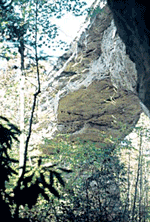 Twin
Arches state natural area is approximately 1,500 acres located in parts
of Fentress, Scott, and Pickett Counties and contains two impressive geological
formations known as the Twin Arches. These arches form the largest natural
bridge complex known in Tennessee and represent one of the world’s
largest such complexes. The two sandstone arches are situated end-to-end,
and are commonly referred to as the North and South Arches. The South
Arch is the tallest at 103 feet high. It has a clearance inside the arch
of 70 feet and its span is 135 feet between the inside base of the feet.
The North Arch is 62 feet high with a clearance of 51 feet and a span
of 93 feet.
Twin
Arches state natural area is approximately 1,500 acres located in parts
of Fentress, Scott, and Pickett Counties and contains two impressive geological
formations known as the Twin Arches. These arches form the largest natural
bridge complex known in Tennessee and represent one of the world’s
largest such complexes. The two sandstone arches are situated end-to-end,
and are commonly referred to as the North and South Arches. The South
Arch is the tallest at 103 feet high. It has a clearance inside the arch
of 70 feet and its span is 135 feet between the inside base of the feet.
The North Arch is 62 feet high with a clearance of 51 feet and a span
of 93 feet.
The tops of the arches support vegetation adapted to dry conditions and include a mixed pine-oak-heath community and a fragile moss-lichen community. The heath component is primarily comprised of various blueberry shrubs (Vaccinium spp.) and huckleberry (Gaylussacia spp.). The vegetation appears stunted because of the harsh conditions related to rock outcropping and shallow soil. The moss and lichens that cover exposed sandstone are subject to trampling, and visitors should exercise caution where they walk to minimize impact. The vegetative cover on the plateau along the trail from the parking area to the arches is dominated by scarlet oak along with chestnut and white oak, red maple, sourwood, blackgum, and Virginia and shortleaf pine.
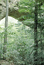 The
arches rise high above the deep gorge that was formed over geological
time by the many tributaries that cut into the sandstone while draining
into the South Fork of Cumberland River. These tributaries include Charit
Creek, Andy Creek, Middle Creek, and Mill Creek. They provide ample site
conditions to support moist, rich, mixed forest communities within the
gorges. Another significant geological attribute is the occurrence of
numerous sandstone rock houses formed below the bluffs. There are also
sandstone barrens scattered along the top of the gorge bluffs that support
populations of needlegrass, little bluestem, and blazing star. Rare species
including the Lucy Braun snakeroot (Ageratina luciae-brauniae)
and Cumberland sandwort (Arenaria cumberlandensis) occur at Twin
Arches. The scenic views from the arches of forest and the vast gorges
are additional attractions of the natural area. It is also a unique area
for birding, as you can sit on the arches and you look down into a mature
forest canopy where warblers flitter below. Twin Arches is one of two
designated state natural areas in the Big South Fork Recreation Area that
are managed by the National Park Service.
The
arches rise high above the deep gorge that was formed over geological
time by the many tributaries that cut into the sandstone while draining
into the South Fork of Cumberland River. These tributaries include Charit
Creek, Andy Creek, Middle Creek, and Mill Creek. They provide ample site
conditions to support moist, rich, mixed forest communities within the
gorges. Another significant geological attribute is the occurrence of
numerous sandstone rock houses formed below the bluffs. There are also
sandstone barrens scattered along the top of the gorge bluffs that support
populations of needlegrass, little bluestem, and blazing star. Rare species
including the Lucy Braun snakeroot (Ageratina luciae-brauniae)
and Cumberland sandwort (Arenaria cumberlandensis) occur at Twin
Arches. The scenic views from the arches of forest and the vast gorges
are additional attractions of the natural area. It is also a unique area
for birding, as you can sit on the arches and you look down into a mature
forest canopy where warblers flitter below. Twin Arches is one of two
designated state natural areas in the Big South Fork Recreation Area that
are managed by the National Park Service.
SITE MANAGEMENT:
Big South Fork National River and Recreation Area Park Headquarters, 4564 Leatherwood Road, Oneida, Tennessee 37841, phone (865) 569-9778; Division of Natural Areas, 401 Church Street, 7th Floor L&C Annex, Nashville, TN 37243, phone (615) 532-0431; Division of Natural Areas – East TN office, 3711 Middlebrook Pike, Knoxville, TN 37921, phone (865) 594-5601.
PUBLIC ACCESS:
Public access is allowed; parking and hiking trails are provided.
DIRECTIONS:
From Crossville, travel north on U.S. Highway 127 toward Jamestown. From Jamestown, take State Route 154 toward Pickett State Park. Turn right on Fork Ridge Rd. Turn left on to Divide Road for 3.5 miles. Turn right on Twin Arches Road and drive two miles to the trailhead.
