


| COUNTY: | Sullivan | ACREAGE: | 52 |
| 7.5' QUADRANGLE: | Keenburg | OWNERSHIP: | Private |
| PHYSIOGRAPHIC PROVINCE: |
Ridge and Valley | YEAR DESIGNATED: |
1973 |
DESCRIPTION: |
 Morril's
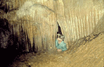
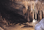
Cave State Natural Area is located in Sullivan County. It has more than
37,000 feet of mapped passages on two levels. Morril's Cave is commonly
called Worley's Cave locally and is known for its voluminous size with
rooms more than 75 feet wide and 250 feet long with high ceilings that
often exceeds 100 feet. It is noted for its beautiful formations within
its eight to ten miles of passages. The lower level of the cave contains
a perennial creek complete with various fishes, white crayfish, and salamanders.
Morril's
Cave State Natural Area is located in Sullivan County. It has more than
37,000 feet of mapped passages on two levels. Morril's Cave is commonly
called Worley's Cave locally and is known for its voluminous size with
rooms more than 75 feet wide and 250 feet long with high ceilings that
often exceeds 100 feet. It is noted for its beautiful formations within
its eight to ten miles of passages. The lower level of the cave contains
a perennial creek complete with various fishes, white crayfish, and salamanders.
 An
unearthed prehistoric stonewall some six feet high, built of rocks of
various sizes, is evidence that the cave was likely inhabited by aboriginal
people. It is unknown when the first settler entered Morril's Cave, although
it has been written that settlers surely would have encountered the cave
by the beginning of the 1800's. Nothing is known of the cave until it
became the property of Elias S. Worley. Locally, the cavern is often still
referred to as Worley Cave. A large amount of saltpeter was mined from
the cave early in the Civil War. A mill was operated in the early 1900's
where the stream exits at the lower entrance of the cave. It was said
that the stream's volume was "sufficient, even in severest drought,
to turn the undershot wheel of a large mill."
An
unearthed prehistoric stonewall some six feet high, built of rocks of
various sizes, is evidence that the cave was likely inhabited by aboriginal
people. It is unknown when the first settler entered Morril's Cave, although
it has been written that settlers surely would have encountered the cave
by the beginning of the 1800's. Nothing is known of the cave until it
became the property of Elias S. Worley. Locally, the cavern is often still
referred to as Worley Cave. A large amount of saltpeter was mined from
the cave early in the Civil War. A mill was operated in the early 1900's
where the stream exits at the lower entrance of the cave. It was said
that the stream's volume was "sufficient, even in severest drought,
to turn the undershot wheel of a large mill."
 A
local resident John Morril, led many explorations of the cavern "near
the turn of the century." Much confusion has arisen over the years
about the proper spelling of the name. It has been called Morrell, Morrill,
Morrils, Morrels, Mirrells, Worley's and even Worlie's Cave. The issue
was resolved in 1980 by the U.S. Board on Geographical Names when it approved
the name Morrell Cave. The Natural Areas Preservation Act, however has
not been amended to change it from Morril's Cave since it was designated
in 1973.
A
local resident John Morril, led many explorations of the cavern "near
the turn of the century." Much confusion has arisen over the years
about the proper spelling of the name. It has been called Morrell, Morrill,
Morrils, Morrels, Mirrells, Worley's and even Worlie's Cave. The issue
was resolved in 1980 by the U.S. Board on Geographical Names when it approved
the name Morrell Cave. The Natural Areas Preservation Act, however has
not been amended to change it from Morril's Cave since it was designated
in 1973.
SITE MANAGEMENT:
Private ownership. Division of Natural Areas, 401 Church Street, 7th Floor L&C Annex, Nashville, TN 37243, phone (615) 532-0431; Division of Natural Areas - East TN office, 3711 Middlebrook Pike, Knoxville, TN 37921, phone (865) 594-5601.
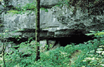
PUBLIC ACCESS:
The site is privately owned. Visitors must follow the directions provided below to the landowner's house. Upon arriving, go to the front porch of the landowner's house where the sign-in sheet and the cave gate keys are kept. Sign in and obtain a key to the cave gate. Lock the gate behind you after entering the cave and secure the key where it will not be lost. Lock the gate after you leave the cave and return the key to the porch before leaving the site. You may go into the cave even if the landowner is not home.
DIRECTIONS:
From Elizabethton take U.S. Highway 19E/State Route 37 north toward Bunker Hill and Bluff City. Turn right on Chinquapin Grove Road. Stay on this road and travel north toward the South Fork of the Holston River. Turn left, heading west on Dry Branch Road, paralleling the South Fork of the Holston River. Turn left on Timber Ridge Road. Go about one mile. Entrance to the property is on the left.
