


| COUNTY: | Franklin | ACREAGE: | 750 |
| 7.5° QUADRANGLE: | Pitcher Ridge | OWNERSHIP: | State of Tennessee |
| PHYSIOGRAPHIC PROVINCE: | Cumberland Plateau | YEAR DESIGNATED: | 2006 |
DESCRIPTION: |
 The Walls of Jericho
is a 750-acre natural area that is within the 8,943-acre Bear Hollow Mountain
Wildlife Management Area (WMA), which is contiguous to the Skyline WMA
in Alabama. Both of the public lands on the Tennessee and Alabama side
total 21,453 acres. The initiative to acquire this land was a lengthy
project completed by The Nature Conservancy in Tennessee and Alabama.
The natural area is approximately twelve miles south of Winchester in
southern Franklin County. The southern boundary of the natural area follows
the Alabama Tennessee state line where the actual “Walls of Jericho”
is located.
The Walls of Jericho
is a 750-acre natural area that is within the 8,943-acre Bear Hollow Mountain
Wildlife Management Area (WMA), which is contiguous to the Skyline WMA
in Alabama. Both of the public lands on the Tennessee and Alabama side
total 21,453 acres. The initiative to acquire this land was a lengthy
project completed by The Nature Conservancy in Tennessee and Alabama.
The natural area is approximately twelve miles south of Winchester in
southern Franklin County. The southern boundary of the natural area follows
the Alabama Tennessee state line where the actual “Walls of Jericho”
is located.
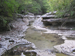
The “Walls” is an impressive geological feature that forms a large bowl shaped amphitheater. Embedded in the limestone are bowling ball size holes from which water drips and spouts, creating a unique water feature. This amphitheater gives rise to steep 200-foot sheer rock walls that creates the natural feature defining the amphitheater. Turkey Creek drains through the “Walls” and has been an active geological force in creating the amphitheater. The natural area forest is comprised of maples, oaks, hickories, tulip tree, American beech, eastern red cedar, and many other plants commonly associated with limestone. The forestland beyond the “Walls” feature is noteworthy with its many bluffs, large rock outcroppings, caves, and sinkholes.
Not only is the “Walls” significant as a geological feature,
the natural area is also important because of its biological richness.
The Turkey Creek drainage, which bisects the natural area from north to
south, supports the state endangered rare limerock arrowwood (Viburnum
bracteatum). This is one of only three known occurrences in the state.
Other rare species occur in the Turkey Creek watershed. The protection
of Turkey Creek also helps protect downstream the Upper Paint Rock watershed
where numerous rare mussel and fish species occur in the Paint Rock River.
SITE MANAGEMENT:
TWRA, P.O. Box 41489, Nashville, TN 37204, Phone 615-781-6622; Division of Natural Areas, 401 Church Street, 7th Floor L&C Annex, Nashville, TN 37243, (615) 532-0431.
PUBLIC ACCESS:
See map with trails at https://www.tn.gov/twra/gis-maps. The access on the Tennessee side is only complete to the stateline, when finished it will connect to the existing trail on the Alabama side that takes you to the Walls. This is expected to be complete in fall 2006. There is no horseback riding permitted or hunting allowed in the natural area.
DIRECTIONS:
From Nashville take I-24 east toward Chattanooga. Take exit 127 on Highway 64 and turn toward Winchester. Stay on Highway 64 for about 15 miles and turn south on Hwy 16 and go 16 miles to the trailhead on the Tennessee side. The Alabama trailhead is approximately two miles south of the Tennessee trailhead and one mile south of the stateline.
