


| COUNTY: | Bledsoe and Van Buren | ACREAGE: | 16,181 |
| 7.5' QUADRANGLE: | Spencer, Sampson, Brockdell, Lonewood & Bald Knob |
OWNERSHIP: | State of Tennessee |
| PHYSIOGRAPHIC PROVINCE: |
Cumberland Plateau | YEAR DESIGNATED: |
1974 |
DESCRIPTION: |
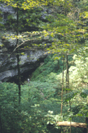 |
| Photo courtesy of A. Cogging |
Fall Creek Falls had its start in 1935 when the National Park Service began buying the land. The first park facilities were constructed under the Works Project Administration. The park was turned over to the Tennessee Department of Conservation in 1944. The state resort park facilities, which are excluded from the natural area, were developed in 1968. The earliest residents of this area were Native Americans followed by the early white pioneers who began farming, logging, and mining the area during the late 1800's. Evidence of their stay in the area can still be seen throughout the natural area and park. TWRA manages hunting during the regular statewide hunting season in certain locations of the park that are designated as a Wildlife Management Area. Consult the latest hunting guide for dates and regulations.
SITE MANAGEMENT:
Fall Creek Falls State Park (www.tnstateparks.com/FallCreekFalls/), Route 3, Pikeville, TN 37367, phone (423) 881-3297. Tennessee Wildlife Resources Agency (https://www.tn.gov/twra), Region III, 464 Industrial Blvd., Crossville, TN 38555, phone (931) 484-9571. Division of Natural Areas, 401 Church Street, 7th Floor L&C Annex, Nashville, TN 37243-0447, phone (615) 532-0431.
PUBLIC ACCESS:
Public access allowed. The natural area is operated by Tennessee State Parks. There is parking, over 30 miles of hiking trails, backcountry camping, a nature center, and picnic areas available. Fall Creek Falls State Park is a resort park with a restaurant, cabins and inn rooms, meeting space, a swimming pool and a golf course.
DIRECTIONS:
Fall Creek Falls is located between Spencer and Pikeville and can be accessed via Highway 111 or Highway 30. Entrances are along Highway 284 that bisects the state park and natural area. The southern entrance is 12 miles down Highway 284 from the Highway 111 junction, and the northern entrance is three miles down Highway 284 from the Highway 30 junction.
