


| COUNTY: | Maury | ACREAGE: | 2,135 |
| 7.5' QUADRANGLE: | Columbia, Glendale, Verona | OWNERSHIP: | State of Tennessee |
| PHYSIOGRAPHIC PROVINCE: |
Central Basin | YEAR DESIGNATED: |
2002 |
DESCRIPTION: |
 The
Duck River Complex is a 2,135-acre natural area complex in Maury County
that consists of six natural areas within the 12,800-acre Yanahli Wildlife
Management Area (WMA). It is managed by the Tennessee Wildlife Resource
Agency as a WMA. These natural areas nested within the WMA support federal
and state listed species often associated with cedar glades, significant
native plant communities, or natural features such as subterranean karst
caves, sinkholes, barrens, forests, and streams.
The
Duck River Complex is a 2,135-acre natural area complex in Maury County
that consists of six natural areas within the 12,800-acre Yanahli Wildlife
Management Area (WMA). It is managed by the Tennessee Wildlife Resource
Agency as a WMA. These natural areas nested within the WMA support federal
and state listed species often associated with cedar glades, significant
native plant communities, or natural features such as subterranean karst
caves, sinkholes, barrens, forests, and streams.
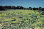
Included are the Columbia Glade (327-acres), Moores Lane Glade (331-acres), and Sowell Mill (306-acres). All of which are cedar glade ecosystems. Rare plants found here include the federally endangered leafy prairie-clover (Dalea foliosa), limestone blue star (Amsonia tabernaemontana var. gattingeri), limestone fame-flower (Talinum calcaricum), Tennessee milk-vetch (Astragalus tennesseensis), and glade cress (Leavenworthia exigua var. exigua). The Howard Bridge Glade (321-acre) is comprised of cedar glade habitat, woodlands, and karst topography. Duck River bladderpod (Lesquerella densipila) occurs here. The Rummage Cave site (50-acre) supports a rare woodrat population and the federally endangered gray bat (Myotis grisescens). It is a short horizontal cave that terminates in five successive oval rooms about 15- feet high and 30 feet wide. Cheeks Bend (800-acre) includes high quality representative cedar glades, scenic bluffs overlooking the Duck River, and extensive cedar and hardwood forests.
The importance of the Duck River Complex is also enhanced because of its association with the Duck River State Scenic River. There are thirteen miles of the 30-mile state scenic river corridor that flows through this 12,800-acre public land. The Duck River is noted for rich faunal diversity particularly the several federal endangered mussel species that occur there. These natural areas were designated to assure that federal and state listed species were protected when TVA transferred the Columbia Dam lands to the State for public use. There is a parking area and a two-mile trail at Cheeks Bend that has bluff vistas and access to a small cave.
SITE MANAGEMENT:
Tennessee Wildlife Resources Agency, PO Box 40747, Nashville, TN 37204, phone (615) 781-6500; Division of Natural Areas, 401 Church Street, 7th Floor L&C Annex, Nashville, TN 37243 phone (615) 532-0431.
PUBLIC ACCESS:
Public access is allowed and there is a two-mile trail and parking area at Cheeks Bend.
DIRECTIONS:
The parking area at Cheeks Bend is on Cheeks Bend Road one mile south of Sowell Mill Pike approximately two miles east of I-65. From I-65 exit to highway 412/99 and head west approximately one mile and turn left on Rock Springs Road and go approximately four miles to Sowell Mill Pike and turn left and go approximately three miles and turn right on Cheeks Bend Road.
